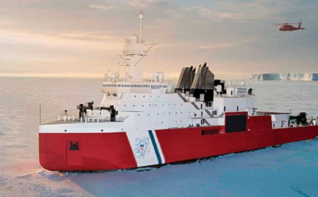


Subsea engineers test robots to tracking oil spills under the arctic ice
As sea ice continues to melt in the Arctic and oil exploration expands in the region, the possibility of an oil spill occurring under ice is higher than ever. But how first responders will deal with oil trapped under ice in such an extreme and remote environment is a huge unresolved question.
WHOI engineer Amy Kukulya said:
“With the opening of the Northwest Passage a few years ago and more commercial ships routinely traveling through the area, there have been concerns among various government agencies that there’s no real infrastructure in place to respond to an oil spill below the ice. From a logistics standpoint, it’s very challenging to get resources to the Arctic.”
Kukulya is leading multiagency collaboration aimed at developing cutting-edge sensors and autonomous robot capabilities that will help improve oil spill responders’ situational awareness and decision making during an emergency. She said:
“As oceanographers, we see a critical need for autonomous underwater vehicles (AUVs) that can survey spills under ice over long distances.”
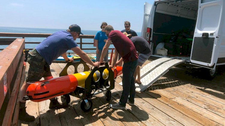
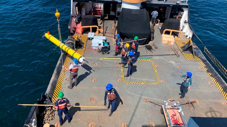
As part of the effort, she and her colleagues deployed a series of AUVs in late August off the coast of Santa Barbara, California to test the vehicles’ oil spill detection capabilities for rapid response during a real-world maritime oil spill. Collaborators on the project include the Department of Homeland Security (DHS), the U.S. Coast Guard (USCG), the U.S. Environmental Protection Agency (EPA), the National Oceanic and Atmospheric Administration (NOAA), the Bureau of Safety and Environmental Enforcement (BSEE), Monterey Bay Aquarium Research Institute (MBARI) and the Arctic Domain Awareness Center (ADAC).
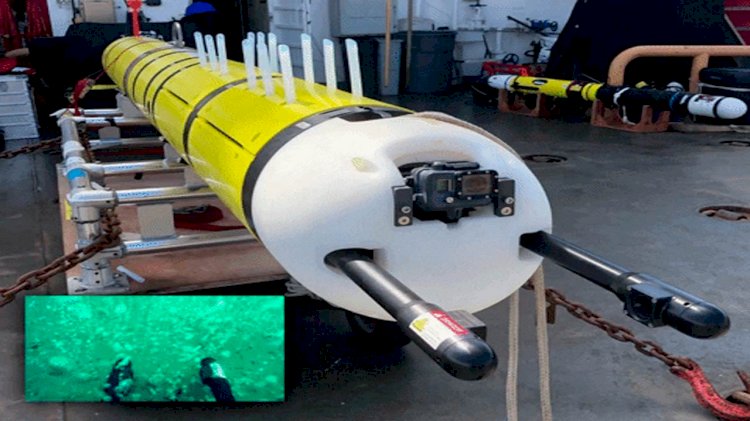
The field program featured two complementary AUVs, a REMUS-600 outfitted with custom oil sniffing and sampling capabilities, and a Long Range Autonomous Underwater Vehicle (LRAUV), a new class of Arctic AUVs funded by DHS to provide a fast and persistent oil spill response for ice covered oceans.
The original LRAUV was initially developed at MBARI under the leadership of James Bellingham, now WHOI’s director of the Center for Marine Robotics (CMR). The latest model, which is still being developed in conjunction with MBARI engineers, is designed specifically to detect oil spills under ice. Bellingham said:
“Our goal is to provide the Coast Guard with greater awareness in the event of a real-world spill, and the ability to understand an incident while there is still time to react.”
The vehicle can be launched into open water from shore, sea ice, ship or helicopter and is an ultramarathoner in the AUV world: it can operate continuously for more than two weeks over a distance of 620 miles (1,000 kilometers).
Dana Tulis, director of emergency management for the Coast Guard, says the new vehicle delivers on a critical and unmet need: fast and efficient data collection that can inform response management in remote and difficult-to-access areas.
Kukulya said:
“If you’re in a remote Arctic environment, rather than deploying a huge vessel, it would be ideal to have these easy-to-deploy robotic vehicles collect information from below the surface. It’s a perfect complement to aerial drones, which we use to fly over remote areas instead of large planes. Embracing the latest technologies like this will allow us to save big on resources when it comes to oil spill response in the open ocean and in the Arctic. And, they can also help with with more common spill response in non-remote areas."
Kukulya says a dozen LRAUV's have already been built by MBARI, and a thirteenth is underway with WHOI as part of the oil response collaboration.
The prototype fills a void in marine robotics between underwater gliders—which can travel long distances but lack the power and payload capacity to carry an extensive suite of sensors—and standard AUVs which typically operate for only 24 hours or less. It builds off MBARI’s noncommercialized underwater vehicle platform—called a Tethys LRAUV—to which various technologies have been added over time. This includes sonar mapping, navigation systems, and specialized sensors that can detect where oil is spreading—and where it is not. First responders can use this information to efficiently track an actual oil spill remotely as it’s happening.
Among the LRAUV’s key features, according to Kukulya, is a “buoyancy engine” which allows the vehicle to shift its internal weight and change its overall buoyancy so it can drift at zero propeller speed. This helps maximize endurance so it can rove for weeks on a single battery charge.
In previous field tests of the LRAUV’s capabilities in Monterey Bay, California, the researchers used a green, biodegradable dye in the ocean to simulate an oil plume. The LRAUV successfully tracked patches of the dye for hours as it drifted through the water, surfacing every few minutes to transmit data for review and analysis by the researchers.
During the more recent testing at the Santa Barbara site, the team conducted another simulated spill, only this time they used real oil, not dye. The site has naturally-occurring oil seeps, from which an estimated 20 to 25 tons of oil are emitted from cracks in the seafloor each day.
During the simulated oil spill, the team tested out new gear on the vehicle, including a holographic camera system. Developed by emeritus WHOI biologist Cabell Davis at the marine technology company he founded, Seascan, the system sends out laser beams roughly seven times per second to take detailed, three-dimensional images of oil droplets in the ocean. A new WHOI “water gulper” that collects up to a dozen water samples per mission also made its debut.
In addition to new hardware, the team has integrated the Robot Operating System (ROS) onto a ‘backseat’ computer for autonomous behavior adaptations. WHOI research engineer Kevin Ducharme and assistant scientist Erin Fischell wrote and tested these new software capabilities on the REMUS vehicles, which will assist in oil spill rapid response efforts.
Beyond cutting-edge technology itself, one critical success factor in moving the project forward to date has been the highly collaborative and multidisciplinary team approach, according to Tulis. When she visited the Santa Barbara testing site in late September, she was surrounded by engineers and scientists from various areas of expertise all working toward the same goal—integrating the new technologies into Coast Guard responses. She said:
“On a single ship, you had experts in remote sensing and engineering, chemistry, and data management. As I went from station to station, I felt like I was in science camp.”
Lessons learned from the 2010 Deepwater Horizon oil spill taught Kukulya and her team a great deal about the challenges of rapid response. “It took 10 days to get the first AUV in the water, and that was in a place that was easy to access,” she said.
The speed at which first responders could deploy AUVs in the Arctic remains a question, but Kukulya says that in addition to its strength in technology development, WHOI shines in the area of marine operations. She said:
“We’re uniquely positioned in terms of our ability to not only develop cutting-edge technology, but get it deployed in the water very quickly. Eventually, I can envision WHOI becoming the go-to place in the event of an oil spill in the Arctic or anywhere, as well as for rapid-response technology for harmful algae blooms, marine microplastics, or any environmental anomaly in the ocean that needs discrete sampling. We have systems right now in the lab that are ready to respond."